Demand evidence
Corridor, comps, and a documented gap at the node
The case rests on three reads: corridor volume, established down-corridor pricing, and the absence of truck-service activity at the exit itself. The comps support the use type; they do not by themselves validate 563-specific demand.
The gap at the FM 563 interchange
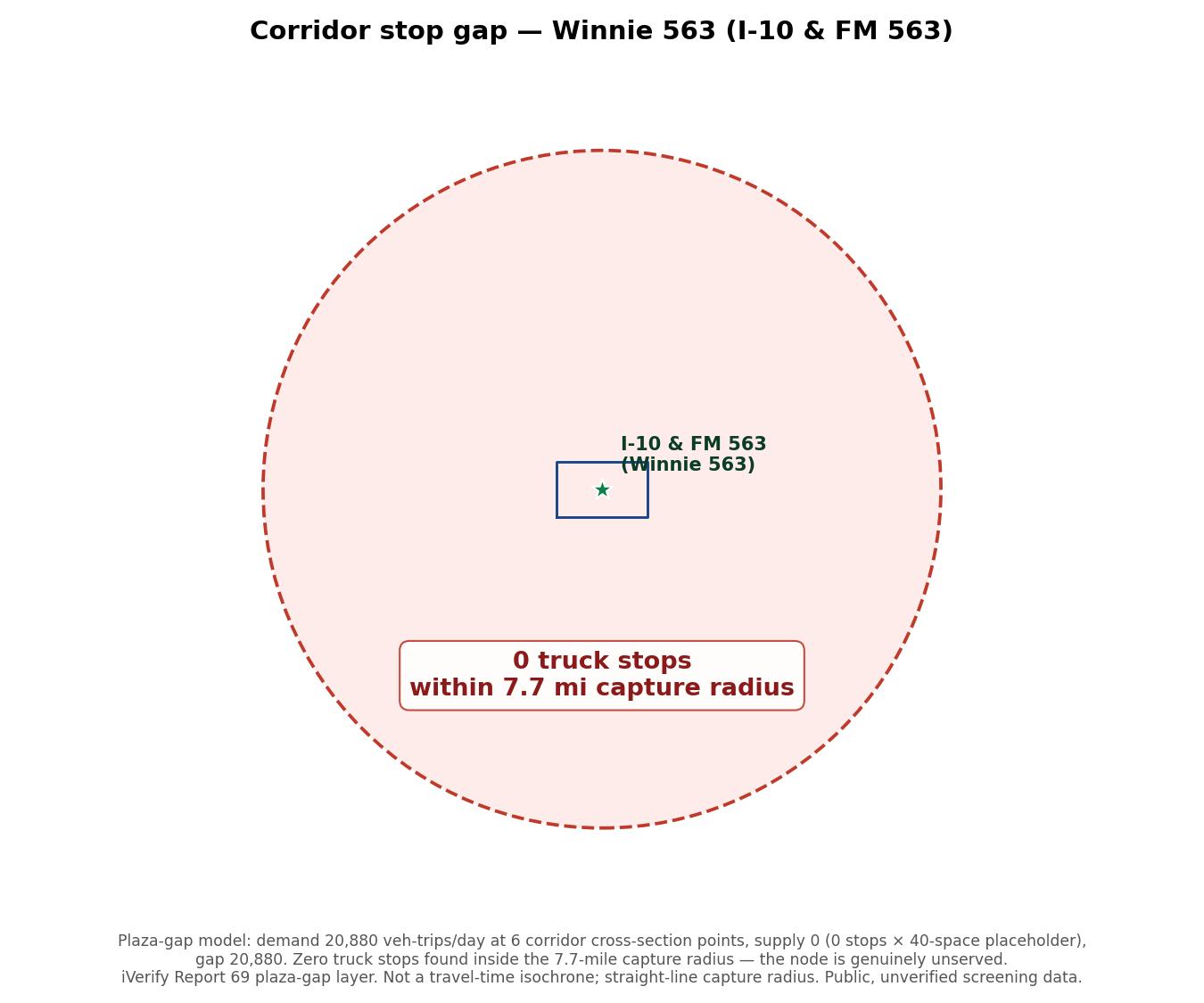
Unlike an interchange with existing truck-stop activity at the exit, iVerify's plaza-gap model finds zero truck stops within a 7.7-mile capture radius of the FM 563 interchange, against a modeled demand of ~20,880 (vehicle-trips/day at six corridor cross-section points) and zero measured supply. This is the node’s own evidence, confirmed against the live model, not an inference from down-corridor comps: it is what makes the pricing-gap thesis below a genuine supply gap rather than a crowded market. Broader non-truck-stop industrial or warehouse activity at the exit is not itemized in this screen - not yet inventoried.
Corridor volume (TxDOT, 2025)
| Road | Average daily traffic |
|---|---|
| I-10 mainline (at the FM 563 interchange) | ~70,002 |
| FM 563 (at the junction) | ~4,331 |
| SH 61 (at the junction) | ~4,224 |
| Combined junction flow | ~76,533 |
I-10 volume is ample for a parking and services use. Combined junction flow (I-10 + FM 563 + SH 61) is shown separately from the I-10 mainline figure - label it as combined flow, never as one road's AADT. The count does not give the truck share or whether the frontage carries permitted access, both validation items.
The product trades in the Beaumont-Port Arthur core
Industrial space leases actively across the Beaumont-Port Arthur market: roughly $0.55-$9 per square foot a year in Beaumont (about $5 on average) and $7-$10 in Port Arthur. The sharpest signal is on SH-73 itself, where a developer recently built two 7,500-square-foot warehouses and is marketing them to petrochemical-support vendors at $10/sqft, triple-net, top of the band, on the same corridor this site feeds. Secured-yard product trades too: a Beaumont industrial-outdoor-storage property is listed at an 8.41% cap, and a Port Arthur outdoor-storage site carries a 15-year net lease.
Parking at and near the node
With zero existing truck stops inside the 7.7-mile capture radius, the paid, secured, reservable product modeled here has no free first-come alternative sitting at the exit to compete with - a different starting position from an interchange where an existing lot already absorbs overflow. The nearest existing supply of any kind sits on the Houston/Baytown side, west of the node; the two largest branded stops sit well east, toward Beaumont. The node reads as sitting between two clusters, not next door to either.
| Stop / lot | Distance & direction (straight-line, from the 563 center) | Read |
|---|---|---|
| FM 563 interchange itself | at the node | zero truck stops within 7.7 mi (confirmed, plaza-gap model) |
| TA Express Baytown South #0277 | ~14 mi WSW | the nearest branded stop of any kind |
| Love’s / TA / Flying J cluster, Baytown | ~20 mi W | four branded stops within a mile of each other |
| Love’s Travel Stop #696, Beaumont | ~31 mi ENE | 115 spaces, free first-come |
| Petro Beaumont #304 | ~35 mi ENE | 275 spaces, Reserve-It reserved (paid) |
| Paid lots, Houston metro (broader cluster) | ~34-54 mi W | $10-$20/24-hr and a gated monthly secured yard |
Distances are straight-line from the 563 AOI center (29.8388445, -94.6959965), computed from iVerify's live truck-stop layer, not driving distance or field-measured; confirm before citing precisely. A TxDOT rest area near Hankamer does not appear in this layer within a 50-mile radius of the node, so it is not listed here rather than estimated.
Willingness-to-pay for secured parking is established at both metro ends (reserved spaces at the Beaumont Petro, $10-$20/24-hr and a gated monthly yard in the Houston metro), and there is no paid or free competing product at the node itself to test against. Whether overnight peak demand reaches this node at all, which is what a paid, secured yard here would need to capture, is the load-bearing validation item, alongside the truck share of the I-10 count and the achievable rate. The corridor establishes the rate band; the rate at this node is still to be confirmed.
Carrier demand near the node
The iVerify screen finds about 484 active carriers within ~30 miles, roughly 2,193 power units and 1,812 trailers. Trailers that have to sit somewhere are parking demand. It is a representative sample, not a full demand verification.
Comparable pricing
| Where / what | Signal |
|---|---|
| Beaumont industrial lease | ~$0.55-$9 /sf/yr, about $5 average |
| Port Arthur industrial lease | $7-$10 /sf/yr |
| SH-73 new build (two 7,500 sf warehouses) | $10 /sf NNN, marketed to petrochem-support vendors, top of band, on this corridor |
| Beaumont industrial outdoor storage | Listed at an 8.41% cap |
| Port Arthur outdoor storage | 15-year net lease |
The priced inventory clusters in the Beaumont-Port Arthur core, ~31-35 miles east of this interchange - the pricing gap the thesis rests on. Comps support the use type, not 563-specific demand. iVerify Report 69.
Down-corridor occupancy
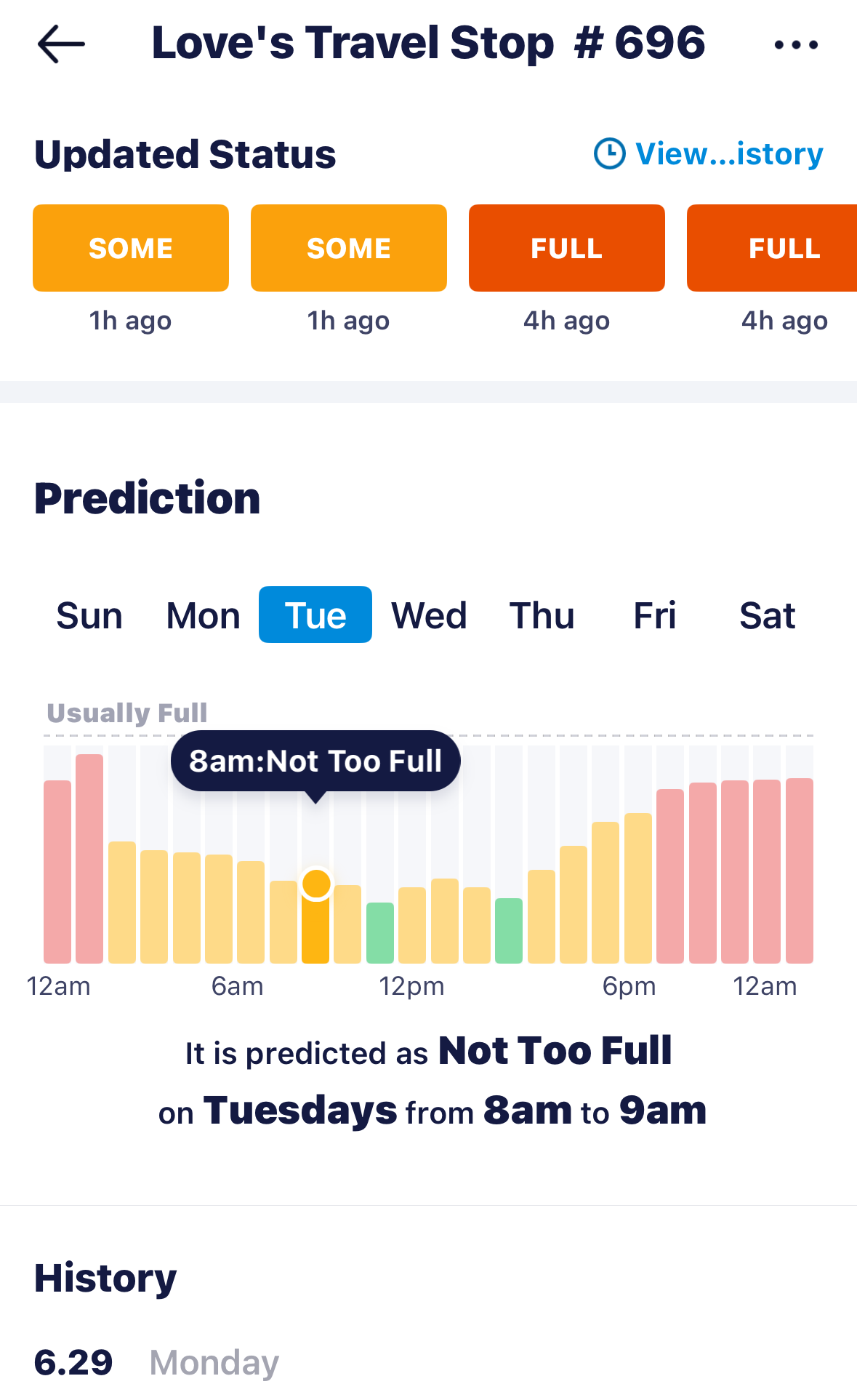
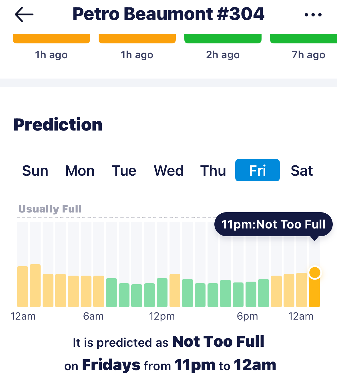
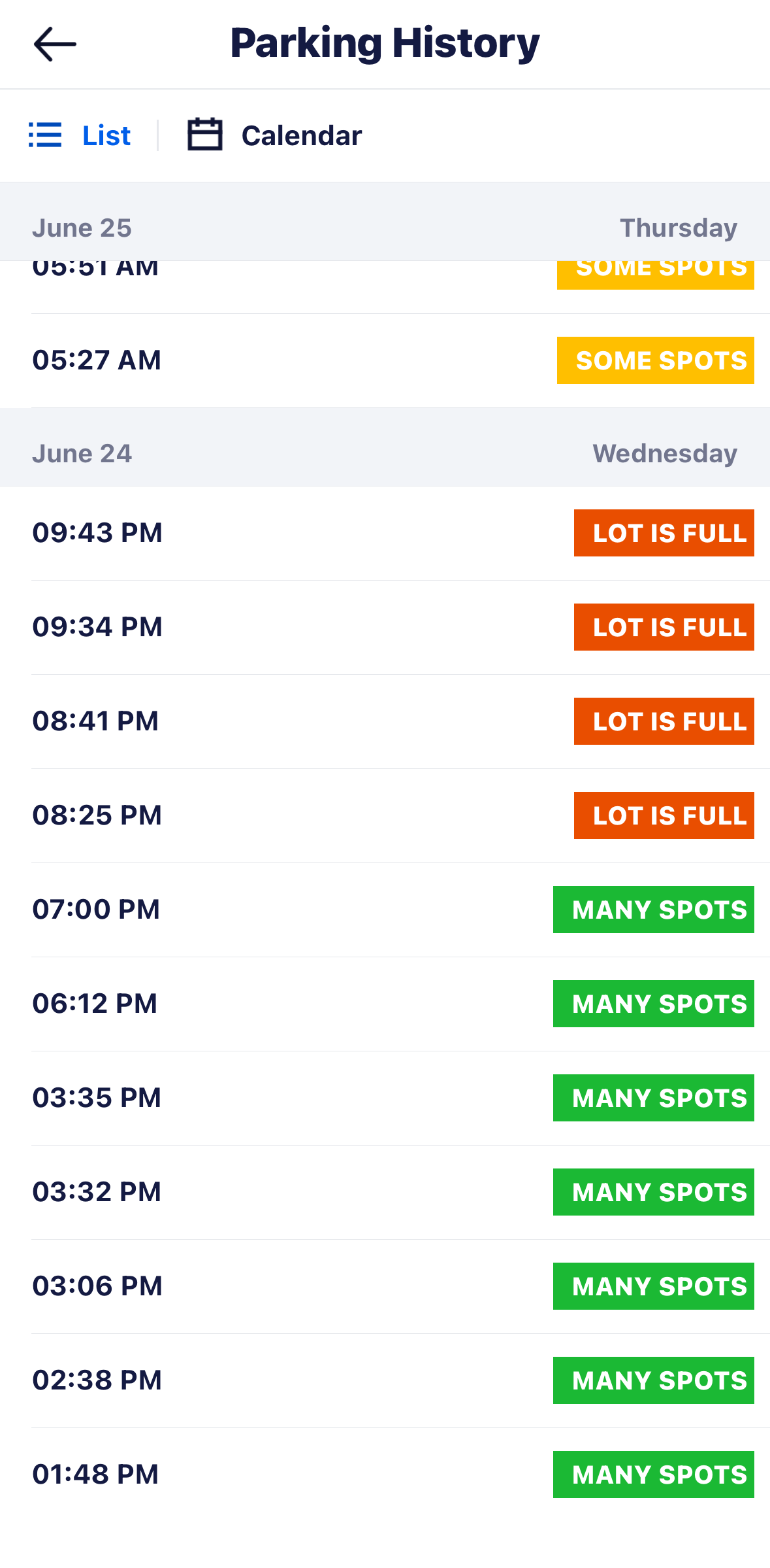
Occupancy down-corridor is strong. The two largest stops toward Beaumont, ~31-35 mi ENE of this node, both read Usually Full on Trucker Path: Love’s Travel Stop #696 (I-10 Exit 843 / Smith Rd, Beaumont, 115 truck spaces) and Petro Beaumont #304 (I-10 Exit 848 / Walden Rd, 275 spaces). Love’s #696 logs Lot is full across weekday evenings (consecutive 8:25-9:43 PM checks) and again overnight (3:25-3:55 AM), easing to Many spots midday. The corridor’s established stops fill, on both ends - the nearest supply of any kind, a Baytown-area cluster, sits ~14-20 mi west. What that does not settle is the FM 563 node itself: whether a new secured, paid yard here captures enough of that demand to fill at the modeled rate remains the validation item - though the zero-stops finding at the node is a stronger starting signal than an already-served interchange would give.
Corridor stop network
| Stop | What is listed |
|---|---|
| TA Express Baytown South #0277 | Nearest branded stop, ~14 mi WSW |
| Love’s Travel Stop #696, Beaumont | ~31 mi ENE, 115 spaces |
| Petro #304, Beaumont | ~35 mi ENE, 275 spaces, reserved (paid) |
103 truck stops within 100 miles in the iVerify database; zero within the 7.7-mile capture radius used by the plaza-gap model above. Distances straight-line from the iVerify truck-stop layer. A TxDOT rest area near Hankamer does not appear in this layer and is not listed rather than estimated. Listing-level (Allstays, TruckMap, Love’s locator), not field-verified: whether they allow long-term trailer storage, their exact counts, and how full they run are open. iVerify Report 69.
An existing freight node
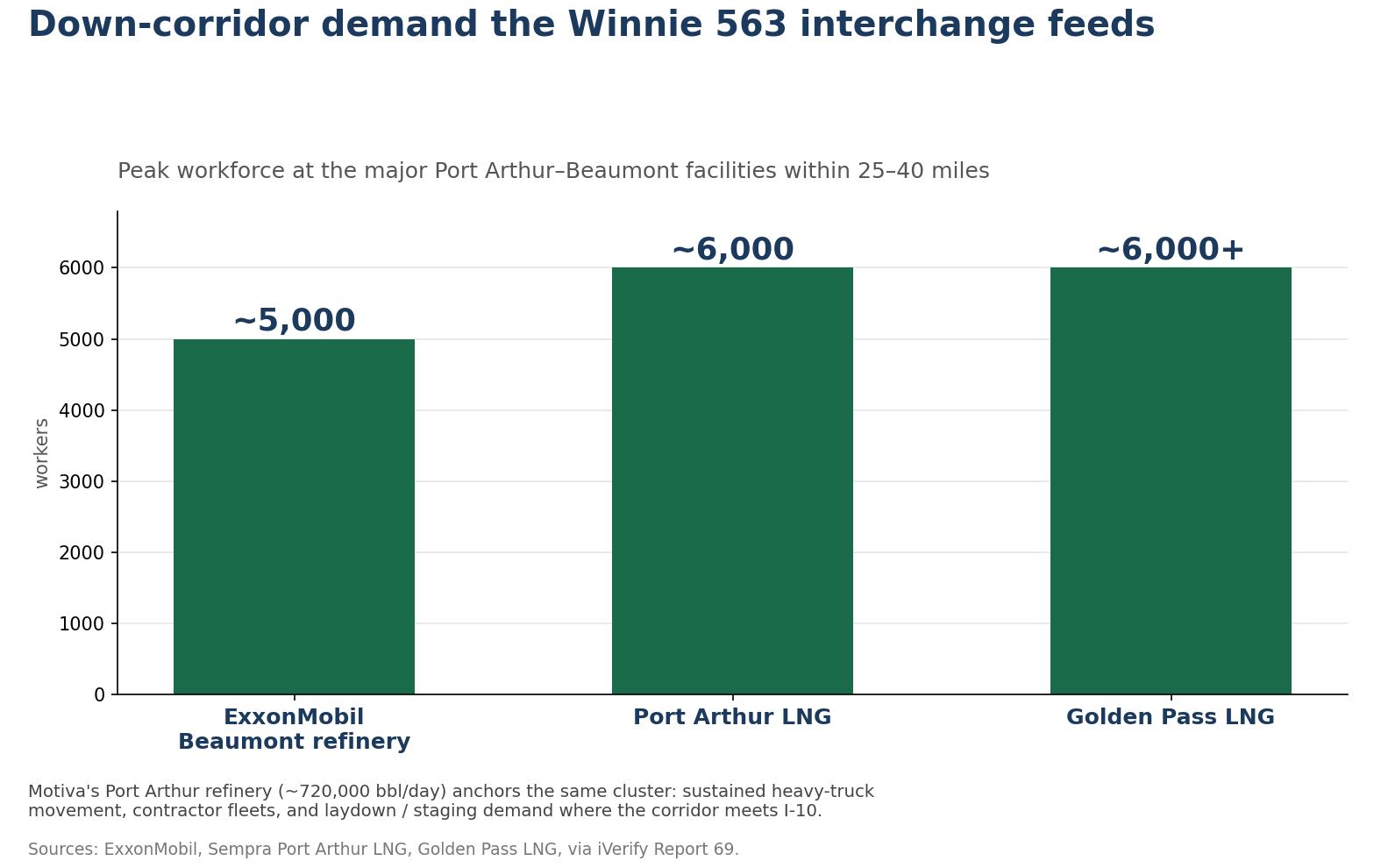
The corridor feeds a heavy industrial region. Within the wider Beaumont-Port Arthur area sit Motiva’s Port Arthur refinery (~720,000 bbl/day), ExxonMobil’s Beaumont refinery (~2,700 ac, ~2,000 staff plus ~3,000 contractors), and two LNG megaprojects under construction, Port Arthur LNG (~6,000 construction jobs at peak; Phase 2 added 2025; work into 2030-31) and Golden Pass LNG (6,000+ at peak; Train 1 shipped first cargo April 2026, Trains 2-3 ramping into 2027). That buildout drives sustained heavy-truck movement, contractor fleets, and laydown/staging demand along this corridor. A separate TxDOT need assessment (iVerify Report 69) flags the nearest documented truck-parking need segment as FM 1405 / SH 73 in Chambers County, 6.1 miles away, tier "blue" (secondary need) - I-10 east approach, petrochemical (Cedar Bayou/Mont Belvieu) traffic, near existing public SRAs.
On supply, TxDOT’s 2024 Southeast Texas Truck Parking Action Plan covers this district, where only ~80 of roughly 7,200 regional truck spaces are public, and the department is deploying an I-10 truck-parking availability system. That is a documented corridor constraint, not a measured shortage at this node specifically beyond the zero-stops plaza-gap finding above; the backdrop is real and large, and points the use toward secured staging more than a generic fuel stop.
Refinery figures: Motiva, ExxonMobil disclosures. LNG schedules: Sempra Port Arthur LNG, Golden Pass LNG. Parking supply: TxDOT 2024 SE Texas Truck Parking Action Plan, FHWA Jason’s Law survey. TxDOT need assessment, plaza-gap model, carrier layer: iVerify Report 69.
Development thesis
A freight corridor with a documented gap
The FM 563 interchange sits on I-10 in Chambers County, Texas, on the route into the Port Arthur and Beaumont refinery and LNG corridor. Unlike an interchange with existing truck-stop activity at the exit, the plaza-gap model finds zero truck stops within 7.7 miles of FM 563 - a documented absence of supply, not an inference. It has a six-parcel, multi-owner land position available near the interchange.
The thesis is a pricing gap. Industrial demand and pricing are established in the Beaumont-Port Arthur core, roughly 31-35 miles east of this node (the distance to the two largest branded truck stops there, Love's #696 and Petro #304, now confirmed against the live truck-stop layer), where the priced inventory clusters (see Demand Evidence); land at the FM 563 node carries a lower cost by comparison. The FM 563 site is the lower-cost staging, parking, and laydown point feeding that market, with a second, closer cluster of existing truck-stop supply on the Houston/Baytown side, ~14-20 miles west - the node sits between the two, not adjacent to either. That is why the node itself still has to be confirmed, even with the corridor comps in hand.
See the parcel map under The Winnie 563 Tracts.
The Winnie 563 tracts
I-10 & FM 563: the parcel position
The FM 563 interchange sits on I-10 in Chambers County, Texas. The plaza-gap model finds zero truck stops within 7.7 miles of the interchange - a genuine gap, not an already-served node: the corridor thesis here rests on absence of supply, not on an established interchange the way the corridor's other candidate nodes read. Broader non-truck-stop industrial or warehouse tenancy at the exit is not itemized in this screen - not yet inventoried.
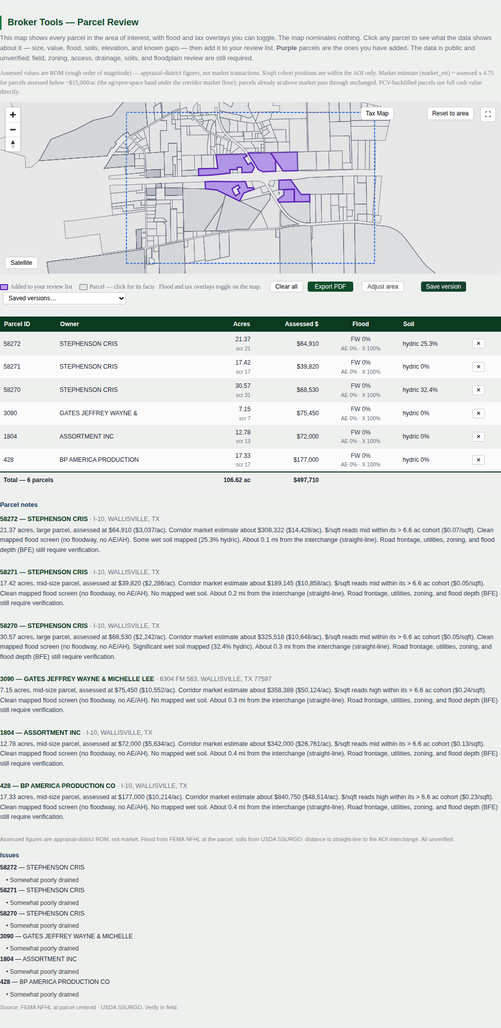
A six-parcel, multi-owner assembly totaling about 106.6 acres straddles I-10 at the FM 563 interchange, all six tracts within 0.1-0.4 miles of the interchange itself. These are candidate land-control targets from the parcel screen, not a selected or listed site; owner willingness, price, access, and per-parcel diligence are open.

| Parcel | Owner | Acres | Assessed (ROM) | Flood | Soil |
|---|---|---|---|---|---|
| 58272 | Stephenson Cris | 21.37 | $64,910 | clean mapped screen | 25.3% hydric |
| 58271 | Stephenson Cris | 17.42 | $39,820 | clean mapped screen | clean |
| 58270 | Stephenson Cris | 30.57 | $68,530 | clean mapped screen | 32.4% hydric |
| 3090 | Gates Jeffrey Wayne & Michelle Lee | 7.15 | $75,450 | clean mapped screen | clean |
| 1804 | Assortment Inc | 12.78 | $72,000 | clean mapped screen | clean |
| 428 | BP America Production Co | 17.33 | $177,000 | clean mapped screen | clean |
| Total · 6 parcels | 106.62 ac | $497,710 |
Assessed values are appraisal-district ROM, not market or list prices. All six parcels read clean on the mapped flood screen (no floodway, no AE/AH); two of six (58270, 58272) carry material hydric soil - a screening signal, not a clearance. Site the yard on the three clean-soil parcels (58271, 3090, 428) and treat the hydric two as the acreage to hold back. Per-parcel flood line and soil borings remain diligence items.
Two development areas, not one tract
The assembly holds room for both the base case and its expansion. The base-case footprint (the ~10-acre secured yard plus ~5 acres of out parcels) is best placed on the clean-soil parcels (58271, 3090, 428), holding the two hydric tracts (58270, 58272) back from the yard floor. The balance of the ~106.6 acres is big enough to test a higher-value logistics use (a transfer or cross-dock facility, a fleet terminal, or a build-to-suit), but only if access, drainage, utilities, soils, and tenant demand validate. That is a conditional development path; it sits outside the base case, the fuel-and-entrance-fee operation priced under Deal economics.
Beyond the base-case yard, the scale of the assembly is what makes the added uses worth naming: with room around the yard, complementary development (a restaurant, a motel, or a fuel-and-service travel-plaza format) builds the kind of mass that turns a parking node into a destination rather than an overflow lot, which lifts the traffic capture the base case rests on - and with zero existing truck stops within 7.7 miles, the node reads as a near-fit for a full truck-plaza use in its own right. These are expansion options, each conditional on demand, access, utilities, and diligence, and each sits outside the base case in Deal economics; the point is that the land can carry them, not that the screen has chosen one.
On I-10 the corridor sits between the Houston-area industrial cluster to the west and the Beaumont-Port Arthur refinery-and-LNG core to the east. Whether that intercept position (cheaper land, off the congestion) can hold trailers, equipment, and contractors staging into either market is a thesis the screen raises, not one it settles.
Utilities
Service reaches this stretch of the corridor - there is existing development at and around the interchange - so the utility question is which providers serve it and at what capacity, not whether service exists. Water, wastewater, and storm drainage for East Chambers County, which includes this node, are handled by the Trinity Bay Conservation District, a public district operating surface-water treatment plants at Winnie and Anahuac. Electric service in this part of Southeast Texas falls in Entergy Texas territory (the former Gulf States Utilities service area); the exact service-territory line and available capacity at this parcel are a diligence item, not yet pulled from the PUCT map. Natural-gas availability at the site is not yet confirmed. None of this substitutes for a utility-capacity and service-commitment check on the chosen parcel, which remains an open validation item - what is settled is that this is a served corridor, not a greenfield with no infrastructure nearby.
Parcel and corridor data: iVerify Report 69 (Winnie 563 / FM 563 interchange study area). Candidate land-control, not a listing.
Land & tracts
The parcels behind the node
The candidate land position is the six-parcel, multi-owner assembly at the FM 563 interchange, detailed under The Winnie 563 Tracts (106.62 acres total). The base case wants ~5-20 acres with a clean truck route inside that assembly; the balance is far upside behind access and flood gating.
See the parcel map under The Winnie 563 Tracts.
Optionality
Energy
The Winnie 563 site may ultimately support far more than truck parking. The location also has long-term potential for solar generation and large electrical users.

Solar
Build only if it stands on its own.
A solar project should make economic sense by itself. Future users are upside, not the justification.
Large power users
Keep the options open.
Possible future users include truck charging, AI computing, industrial facilities, or other high-load operations.
Utility
Work with the utility, not around it.
Water, wastewater, and drainage for East Chambers County are provided by the Trinity Bay Conservation District. Electric service falls in Entergy Texas territory; the exact capacity at this parcel is a diligence item. The opportunity is to build infrastructure that serves both the utilities and future customers.
For illustration
Example parcel
The example is a ~15-acre position at I-10 & FM 563: a ~10-acre secured yard (150-stall layout, priced as the fuel-and-entrance-fee operation in modular scenario 49) plus ~5 acres of out parcels held unimproved, carved from the six-parcel, multi-owner assembly detailed under The Winnie 563 Tracts. Land is carried at $30,000/acre, the proposed asking price (purchase price to be negotiated). Appraisal-district figures are lower and are not the basis. The carve is a planning illustration used to drive a layout and the numbers, not a parcel NSG controls, has optioned, or has surveyed; owner willingness, price, access, and the exact carve are open. The right footprint is the one whose truck route, perimeter, and per-parcel flood line survive diligence.
Soils / grading
Low, flat ground - real flood exposure in the AOI, the six target parcels clear of it
The ground is flat and low-lying (about 2-29 ft elevation across the samples, ~27 ft of relief - the low end is close to sea level, consistent with this Chambers County node's proximity to the coastal marsh). Federal soil-survey data shows 12 mapped units in the AOI: three well-or-moderately-drained, buildable units (Buna, Dylan, Spurger) and four poorly-to-very-poorly-drained hydric units (Bevil, Evadale, Harris, Zummo) that read wet. That points to on-site detention, a heavier pavement section, added foundation cost, and a wetland delineation on the wetter parcels. It is general screening only, no soil borings yet.
Flood exposure across the AOI is real, not a clean screen: 65% of 17 sampled points inside the boundary fall in FEMA’s mapped Special Flood Hazard Area (zones A, AE, VE), concentrated to the south toward the coast. The six target parcels themselves are a different story - broker-PDF-confirmed clean mapped screen (no floodway, no AE/AH) - and they cluster in the AOI’s north, away from the mapped flood. That AOI-vs-parcel distinction is the one to hold onto: the interchange sits in a flood-exposed AOI, but the specific parcels being screened read clear. The per-parcel flood line is still a diligence item, not a settled fact.

Soils
| Series | Drainage | Hydric | Screening read |
|---|---|---|---|
| Buna | Well drained | No | A buildable unit here |
| Dylan, Spurger | Moderately well drained | No | Buildable |
| Kaman, Texla, Vamont | Somewhat poorly drained | No | Detention + fill on the wetter spots |
| Bevil, Evadale | Poorly drained | Yes | Likely-wetland soil |
| Harris, Zummo | Very poorly drained | Yes | Ponds; likely-wetland soil |
| Pits / Water | - | - | Non-soil map units |
12 map units across 22 polygons in the AOI. Buildable: Buna, Dylan, Spurger; wet/likely-wetland: Bevil, Evadale, Harris, Zummo. Of the six target parcels, 58270 and 58272 carry material hydric % (32.4% and 25.3%); the other four read clean. NRCS soil-survey data via iVerify Report 69 (live).
Validation tests before site control
What this screen does not settle, in order:
| Test | Why |
|---|---|
| Permitted, safe truck route in/out | TxDOT may not allow a new I-10 curb cut close to the interchange; access can decide the parcel |
| Per-parcel flood line | The six target parcels read clean in the broker screen, but the AOI carries real mapped SFHA elsewhere - confirm the line on the chosen tract, don't assume from the AOI average |
| Rate & occupancy | Comps prove the use; whether a paid yard fills at the FM 563 interchange, with zero existing stops nearby, is unproven |
| Geotech / soil borings | Confirm detention, pavement, and foundation cost on the chosen parcel, especially the two hydric-flagged tracts |
| Wetland delineation | Bevil/Evadale/Harris/Zummo soils flag likely wetlands in the AOI |
| Operator interest | A user or operator at the modeled rate |
Phase 2 · site control + diligence
Control, then diligence
After the market screen survives and a preferred parcel and ownership path are identified, validation spending follows an acceptable option / PSA path. Once the site can be tied up, this budget buys the evidence needed before construction equity is exposed.
| Item | Why it matters |
|---|---|
| Permitted, safe truck route + curb cut | The highest-leverage item: a clean route in and out from I-10, FM 563, or a connecting road. TxDOT may not permit a new curb cut close to the FM 563 interchange; a non-frontage tract with easy access can be the better candidate. |
| Per-parcel flood line | Zone X at the sampled points is a sample, not a clearance; confirm the line on the chosen tract. |
| Wetland delineation + soil borings | Likely-wetland soils and shrink-swell clay drive detention, fill, pavement, and foundation cost: the numbers that move the budget. |
| Drainage / detention design | Slow-draining clay and a shallow water table mean on-site detention; geotech sets the section. |
| Demand confirmation | Truck share of the I-10 count, and the achievable trucks/day and fuel-uptake at this node, the load-bearing assumption behind the deal economics. |
| Owner willingness + title | Confirm the seller path on the chosen tract or assembly; the screen leans toward private (non-energy) owners as the cleaner path. |
Appendix
Where the operating assumptions come from
Every figure in the calculator and proforma traces to one of the rows below - a source where one exists, and a plainly labeled planning choice where one does not.
| Assumption | Basis |
|---|---|
| 60 trucks/day | A chosen underwriting floor, not a derived forecast. Context, not derivation: I-10 carries ~70,002 vehicles/day at this interchange mainline (this deal's 2025 AADT figure) and 484 active carriers are registered within 30 miles (iVerify Report 69); 60/day is the floor the deal must clear, and the calculator shows the math at any higher number. |
| $14 entrance fee | Sits inside the $10-$20/24-hr paid-parking band observed on this corridor (reserved spaces at the Beaumont Petro; a gated monthly yard in the Houston metro). A price point to validate with operators, not a market-clearing rate. |
| 85% of trucks fuel | Planning assumption, chosen. No survey or comp behind it; the fees-alone break-even in Lender Metrics shows the deal at 0% fueling. |
| 100-gallon average fill / $0.05 per gallon margin | Fill size is a conservative planning choice (Class 8 tank capacity runs well above it). The nickel margin is the floor of the wholesale-to-retail spread documented in the Diesel supply options report (Backup Documents); achievable margin is a validation item, not a settled fact. |
| 25% operating expense ratio | Planning assumption, not yet itemized by category or confirmed against a quote - same label it carries in the calculator. |
Fixed basis behind all of it: $2,473,000 total development cost and $1,608,000 debt, from idevelop scenario 49 - see Deal Economics on the pitch page.
Powered by iVerify Patent Pending
The source data
The screen behind this page is the live iVerify report for this node. iVerify pulls the public data and the table shows what each layer becomes in it.
| Raw data | iVerify output |
|---|---|
| TxDOT traffic counts | Corridor demand signal |
| Parcels (Chambers County) | Owner / size / value / geometry review |
| FEMA flood | Buildable-footprint screen |
| NRCS soils | Soil / grading risk screen |
| USGS elevation | Relief and civil-cost signal |
| Truck-service inventory | Overnight-stop and service-node signal |
| Logistics / warehouse layers | Market context (Beaumont-Port Arthur) |
| Broker tool | Parcel shortlist and action list |
The page shows the outputs: report, parcel facts, method. The raw tables, scoring weights, schema, and extraction logic stay inside the engine.
Traffic
| Road | AADT (2025) |
|---|---|
| Interstate 10 (mainline) | ~70,002 |
| FM 563 (at junction) | ~4,331 |
| SH 61 (at junction) | ~4,224 |
| Combined junction flow | ~76,533 |
2 count stations in the AOI; interchange-ramp counts are not published in this dataset. TxDOT 2025 via iVerify Report 69. The count does not give truck share or whether the frontage carries permitted access, both still to validate.
Backup Documents
Backup, on request
iVerify Report 69, live
Full technical screen for this node: traffic, parcels, flood, soils, topo, corridor comps, truck-service context, and the broker tool.
Scenario 49 proforma workbook (Excel)
The underwriting workbook behind the figures on this site: assumptions, cost detail, sources and uses, three-year cash flow, sensitivity, and audit checks for the fuel-and-entrance-fee operation. Year-3 disposition figures are order-of-magnitude planning values.
Diesel supply options, research report
Terminal and rack landscape, marketer and cardlock partner comparison, wholesale-to-retail price snapshot, procurement paths, and Texas storage compliance for a Winnie fuel program.
DEF strategy, research report
Tote vs. bulk storage sizing, supplier RFQ list, retail price anchors, and a planning margin matrix for a DEF program at this site.
Founder credentials
Founder profile and issued/pending patent summary, from the North Star investor library.
iVerify Report
Open the full iVerify Report 69
The live screening report behind this page, parcel, flood, soils, elevation, traffic, and corridor-demand layers with interactive maps.
North Star Group / iVerify
Developer-led method
North Star Group is a developer-led systems and real estate platform focused on practical site origination, development strategy, infrastructure, and applied AI tools. iVerify is North Star’s corridor-screening and parcel-origination system for freight, IOS, truck-service, and logistics-land opportunities.
Michael Hoffman is the principal of North Star Group, Inc. His background includes real estate development, systems integration, and invention work, with issued patents and pending housing / site-screening concepts. The Winnie 563 package reflects a developer-led method: screen the corridor, isolate candidate parcels, identify the demand signal, prepare a validation budget, and advance only if the economics survive real-world checks.
Contact
Michael Hoffman
North Star Group, Inc.
Fairhope, Alabama
701-770-9118
michaelh@nsgia.com
www.nsgia.com
This is a pre-validation screening package.